Dane Nisbet to be honoured by Sarnia Hockey Association
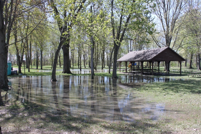
Rising water levels raise concerns in St. Clair Region
June 6, 2020
Alex Kurial
Local Journalism Initiative
Record water levels are being predicted and that could spell trouble for shoreline communities in the Sydenham River watershed.
While erosion along the Lake Huron shoreline has received a lot of attention and some of the areas have had emergency fixes, officials with the St. Clair Region Conservation Authority say high water levels will also affect inland communities.
Measurements taken in Lake Huron and Lake St. Clair have shown a steady increase in water rise throughout 2019 and continuing into 2020.
In Lake St. Clair especially, levels are predicted to equal or surpass even the record highs seen in 1986.
Emily De Cloet, water resources specialist at the St. Clair Conservation Authority, says this is something that needs to be monitored carefully.
“This is something we’re really going to have to keep an eye on, because if these trends are consistent with these projections, and we do see these really high water levels, that’s going to mean that Wallaceburg is going to see high water because the water can’t get out of the Sydenham River into Lake St. Clair, and it’s actually going to push back,” De Cloet said.
“That’s what we saw last summer, and we had static high water levels.”
The causes of high water levels in the area often originate well away from southern Ontario, with Lake Superior in particular playing a part. High precipitation and snow melt in Minnesota and northern Ontario causes water to rise in the westernmost Great Lake, which then flows eastward to Lake Huron and ultimately the St. Clair region.
De Cloet discussed several options that are available to combat these issues, but each one comes with its own restrictions. Water manipulation was one such option, where outflow from Lake Superior to Lake Huron would be regulated through the St. Marys River.
But De Cloet said on its own this would not be enough.
“If we have lots of precipitation and runoff but not evaporation, that’s going to affect how much water there is. Controlling the outflow of Lake Superior can’t mitigate the fact we get a lot of precipitation.
“While there is some control via the St. Marys River, it’s not enough to change water levels significantly downstream where we are,” said De Cloet.
The McKeough Dam is another option to protect those along the Sydenham River from flooding, but each closing of the gates to send water back upstream results in the flooding of rural homes and farms. This option is therefore reserved for more extreme cases.
De Cloet also explained how shoreline armoring, where physical features like large rocks or fences are used to protect against coastal erosion, is also falling short.
Many of these structures were constructed in the 1980s, and are nearing the end of their lifespan. This has been accelerated by increased water activity, as well as wind storms.
NEXT
St. Clair Township cancels summer day camps and ice time
PREVIOUS
Shetland park may have more seasonal sites

Front Page
Dane Nisbet to be honoured by Sarnia Hockey Association
July 27, 2026
Barry Wright/The Independent The board of Sarnia Hockey Association has unanimously approved a plan to have its teams were a memorial patch on its uniform shoulder in honour of Dane Nisbet this season. All A/AA, B/BB and MD teams will wear the patch that has been approved by the Dane’s mom, Tracy. Nisbet is a graduate of Sarnia minor hockey
Read More

Front Page
Sarnia man faces weapons charges after vehicle hit with shotgun blast
July 27, 2026
The Independent A 47-year-old Sarnia man is facing weapons charges after shots were fired at a vehicle on Overlea Crescent. July 23, Sarnia Police were called to a home after a resident found multiple holes in the rear driver’s side door of the vehicle. Neighbours reported hearing gunshots in the area around 10:40 pm the night before. No one was
Read More

Front Page
Petrolia councillor to run in Dawn-Euphemia
July 27, 2026
Heather Wright/The Independent Petrolia Town Councillor Debb Pitel is running for councillor again – just not in Petrolia. Pitel has filed her nomination papers for the Oct. 26 municipal election in the Township of Dawn-Euphemia. The one-term councillor owns a building in Petrolia, allowing her to run for office in 2022. Pitel said at the time that much of her
Read More
Front Page
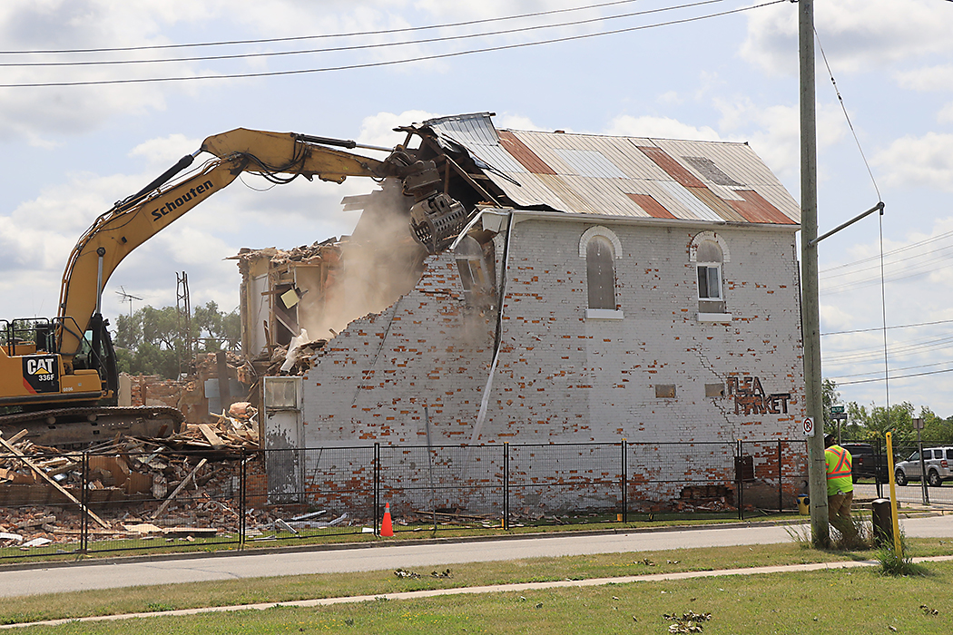
Home of one of Courtright’s first businesses demolished
July 27, 2026
EDITOR’S NOTE: This story has been edited to remove references by a local historian who intentionally provided false information when asked on July 21, 2026 about the history of the building. The Independent The home of the first business in Courtright has been torn down. Demolition of what once was the Cathcart General Store started July 21. The Moore Museum
Read More