Retirement, training deadlines leave Oil Springs without fire chief on July 1

UPDATED: Officials keep an eye on rising flood waters in Central Lambton
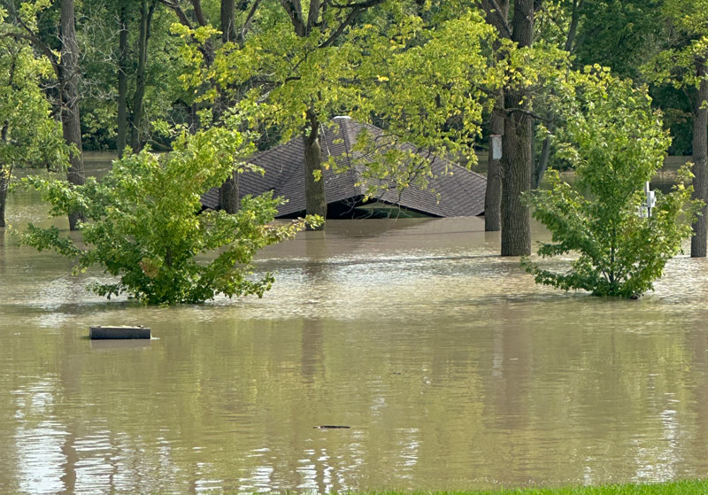
August 25, 2023
Damage in Warwick Township after Wednesday storm expected to be hundreds of thousands of dollars
Brice Stephenson and Jocelyn Polster saw the water rising at Bridgeview Park and went home to get their paddle board.
The couple could be seen paddling around Bridgeview North Thursday where normally there was dry ground. Stephenson even tried to surf on a floating picnic table.
Another paddler – this one in a kayak – made his way around the ball diamonds on the south side of the park, carefully avoiding the water rushing under the Petrolia Line bridge.
Just a few hours later, the park was closed as the water from Wednesday’s heavy rainfall rushed down the Sydenham River and its tributaries and overflowed the banks of Bear Creek. By about 6:30 pm, the water was estimated to be about seven feet above normal.

The rising flood waters also affected the other end of town. Petrolia officials closed Glenview Drive between Kerr and First Street because of the flooding on Bear Creek. It was reopened Friday morning.
An estimated over 100 mm of rain fell Wednesday afternoon in heavy downpours. Ditches in Brooke-Alvinston near Forest Road were filled to the top of their culverts Thursday afternoon and, in some places, water could be seen running off the surface of fields making small waterfalls.
In other spots including Ebenezer Line, water pooled in corn and bean fields. The extent of damage to agricultural crops isn’t known yet.
On Lasalle Line near Old Walnut Road, some crops were still covered in water from a nearby creek. By the dirt on the leaves, it appears the water rose about half way up the stalks.

The flooding is a scenario playing out across Sydenham’s water shed. Ken Phillips of the St. Clair Region Conservation Authority said people camping at AW Campbell Conservation Area are still unable to drive out of the park; the main road is flooded and Phillips says they’re not sure how much damage all the water has done to the road and bridge.
Conservation staff will be able to bring campers who have to get out of the park to the road, where someone will have to pick them up.
At the Warwick Conservation Area, Warwick Fire Rescue and Township workers helped clear the water from the road which stranded half the campground. They were able to get out of the conservation area just after the noon hour.
The Sydenham also caused problems at the Shetland Conservation Area with at least one camper looking for help to tow her trailer out of the park as the water rose dangerously close to the door of her unit.
The conservation authority issued a flood watch in effect until Friday evening saying river banks are expected to be slippery, with the possibility of minor erosion. And Phillips reminds people to avoid watercourses and flooded areas due to slippery banks and swift-moving water.
In Warwick Township, Mayor Todd Case says hundreds of thousands of dollars of damage has been done to roads in the community following torrential rain that dropped between five and seven inches of rain.
And the damage is much higher for countless homeowners in the municipality whose basements filled with water Wednesday evening.
Case declared a state of emergency in the township after learning that a number of gravel roads had been washed out with most of the gravel washed away and that the newly paved Zion Line had a major buckle in the roadway which will need to be rebuilt.
Case also heard from more than 60 homeowners Wednesday and Thursday who either had floods in their homes or roads in their neighbourhood in need of repairs.
Case says by declaring the state of emergency, the township will likely be able to access funding from the provincial government to help ease the financial burden of the storm.
But he too was bracing for more rain saying “there is just no place for it to go at this point.”
The St. Clair Region Conservation Authority says the following roads were still closed by flooding Thursday:
-
- Sexton Road between Zion Line and Egremont Rd
- Bethel Road from Egremont Road to Birman Line
- Zion Line between Nauvoo Rd and London Line
- Warwick Village Road between Birnam Line and Hickory Creek
- Hickory Creek Line from Elarton to Forest Road
- Kingscourt between Confederation Line and Egremont
- Courtright Road between Nauvoo Road and Buttonwood Drive
Meantime, near Alvinston on Dundonald Road in the Glencoe area, a 56 year old Mississauga truck driver lost his life after the road collapsed underneath his rig Wednesday night around 10 pm. OPP say the road collapsed leaving a three meter deep hole.
NEXT
Zion Line remains closed because of flood damage
PREVIOUS
Warwick declares a state of emergency in the wake of flooding

Front Page
Retirement, training deadlines leave Oil Springs without fire chief on July 1
June 17, 2026
Heather Wright/The Independent The retirement of the Oil Springs/South Enniskillen fire chief and new training regulations are creating a unique situation in Oil Springs. The Oil Springs/South Enniskillen Chief Mike Cumming is retiring on June 30. Monday, Oil Springs council appointed John Berdan as the new chief. But Berdan is in administrative limbo because of new training regulations and cannot
Read More

Front Page
Montanino, Jolicoeur among locals picked in OHL Draft
June 17, 2026
Barry Wright/The Independent Defenceman John Montanino led the local contingent drafted at the OHL Priority Selection in Kingston. The Brampton Steelheads selected him in the third round. The Sarnia native played with Detroit-Little Caesars this season. Windsor chose Sarnia’s Cameron Jolicoeur, a power forward from the London Jr. Knights, in the seventh round and the Knights took Grand Bend’s Liam
Read More

Front Page
Lambton plans more permanent shelter beds with Good Shepherd’s Lodge expansion
June 17, 2026
1,700 square-foot addition could hold 42 new beds Heather Wright/The Independent There could soon be more permanent shelter beds in Sarnia at the Good Shepherd’s Lodge. Lambton County is planning an expansion at the Confederation St. facility for up to 42 new permanent shelter beds. The County of Lambton set up a temporary shelter at the former Laurel Lea Church
Read More

Front Page
The dust and the mud at the Alvinston Pro Rodeo
June 16, 2026
The population of Alvinston swelled by a couple of thousand this weekend as the Alvinston Pro Rodeo set up shop at the Brooke Alvinston Inwood Community Centre for the weekend. Cowboys and cowgirls from all over North America came to be part of the action. And there was a big local contingent including Tyler Foster and Rod Weese, World Champions
Read More