Four charged with drug trafficking by Anishinabek Police after stop in Lambton Shores
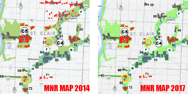
Oops MNR map mistake adds more wetlands in Lambton
July 13, 2017
A mistake by the Ministry of Natural Resources may end up easing some concerns about the Lambton County Draft Official Plan.
The county has faced some stiff opposition from landowners over the document – particularly the increased number of wetland areas. Members of the Concerned Landowners Legal Defence worried they would loose the ability to farm the land or build near it.
An area of St. Clair Township was of particular concern. A township resident whose land had been designated as wetlands in the draft plan called the MNR, which created the map, to ask about why his land was considered wetland.
County Planner Will Nywening says the MNR didn’t know what he was talking about. The ministry’s most current maps didn’t show his land as wetlands.
So officials started digging and soon found out the map in the draft plan was an error. Nywening says someone had been analysing aerial photos and designated the areas wetlands, but they had not been confirmed.
The map Lambton County officials had found on the MNR website in 2014 when the first draft was written, had been taken down shortly afterwards when an MNR official noticed the mistake.
Lambton County officials were never told. And that has led to a lot of concern, and a threat of a lawsuit by the Concerned Landowners Legal Defence group.
Nywening says it is good the landowner, instead of just complaining, “went out and investigated himself” otherwise, the mistake may have never been found.
Municipal leaders hope people hear about the new wetland mapping. The draft official plan is being circulated to all municipalities for one final look and is expected to be approved at the Aug. 2 county council meeting.
While the new map may ease some concern, the CLLD still has a list of about 30 outstanding concerns including a map outlining agricultural areas.
NEXT
Woman voices concern about morale and changes at Meadowview
PREVIOUS
Stocks very low at Petrolia food bank this summer
Front Page
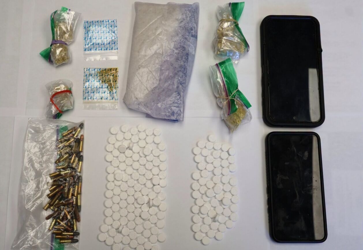
Four charged with drug trafficking by Anishinabek Police after stop in Lambton Shores
July 24, 2026
The Independent Four people have been arrested after a drug trafficking investigation that started in May and ended with a traffic stop in Lambton Shores July 21. Anishinabek Police Service officers stopped a vehicle in Lambton Shores July 21. Police searched the vehicle and found seven grams of fentanyl and 51 hydromorphone tables. A 57-year-old man and 43 year-old woman,
Read More
Front Page
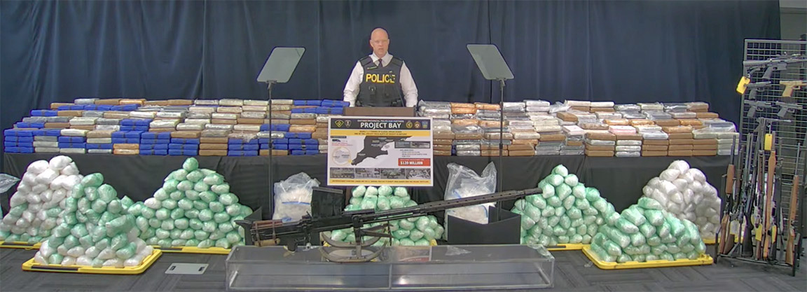
Bluewater Bridge border guards seized 1.1 tonnes of drugs in $139 million bust
July 24, 2026
Heather Wright/The Independent About 1.1 tonnes of the drugs seized in a $139 million drug investigation were seized at the Bluewater Bridge. And a Corunna man is one of 21 people charged in the massive drug ring which netted a total of 1.7 tonnes of cocaine, methamphetamine, opium and oxycodone. The investigation began in Windsor in January 2025. “At that
Read More
Front Page
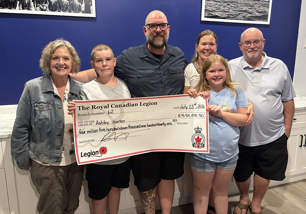
Ashley Norton Caught the Ace
July 24, 2026
Imperial Oil employee takes home $4.5 million in Sarnia Legion Cathy Dobson & Heather Wright/The Independent After 45 weeks, hundreds of thousands of tickets sold, food banks restocked and a whole lot of fun, the Chase for the Ace is over. Thursday, Ashley Norton’s ticket was drawn at the Sarnia Legion. The 44-year-old Imperial Oil maintenance manager chose envelope number
Read More

Front Page
Oil Springs Youth Centre may be OPPs remote workplace
July 23, 2026
Blake Ellis/The Independent A request from the Lambton OPP for a secure, remote workplace has led the Oil Springs council to suggest the OPP use the youth centre in the village. The suggestion was made at the July 14 council meeting, when council reviewed the request from Lambton OPP Operational Support Sergeant Michael Marsh. “I like the idea because they’re
Read More